Landslides are the greatest disasters on planet earth. Collapse - what is it? Causes and consequences of landslides Severe landslides
The biggest collapse in the history of the earth
Most mountain falls occur in the spring. This is no coincidence. Autumn rains wet the rocks and water collects in their cracks. In winter, it freezes and at the same time expands, puts pressure on the walls, and pushes cracks apart. Thus, acting repeatedly, the ice “wedges” loosen the blocks and split them into pieces. Finally, the moment comes when individual parts break off from the parent rock and fall down.
Often the power of ice, acting quietly, is actively assisted by flowing waters. Washing the slope of the valley, they gradually undermine the ice, and at some point, under the influence of their own gravity, the washed away rocks collapse down and fill up the river valley. Mountain lakes appear in these places. An example is such pearls among lakes as Ritsa, Lake Sarez and many others.

Of all the collapses that occurred in historical times, the largest was Usoi; it occurred in the Central Pamirs in the area of the former village of Usoy. Here, on the night of February 17-18, 1911, from the slopes of the Muzkol ridge, from a height of about 5,000 meters above sea level, a fantastic amount of earth and rock fragments fell into the valley of the Murgab River.
A strong earthquake was observed in the same area simultaneously with the collapse.
When scientists carried out a thorough examination of the area where everything happened and made the necessary calculations, it turned out that, firstly, the epicenter of the earthquake coincided with the site of the collapse and, secondly, the energy of the earthquake and the collapse were equal. This means that the collapse was the cause of the earthquake.
But the mystery of the Usoi collapse for a long time remained the question of its phenomenally large size. Until now, no one knows whether there has ever been a similar collapse on the globe in historical times.
Only after many years of research did geologists reveal the secrets of the Usoi collapse. It turned out that the strata that make up the mountain slopes are inclined towards the Murgab River valley. The mass of the rubble consisted of rocks that were stronger than those that underlay them. Over the course of thousands of years, the Murghab River washed away the steep right slopes of the valley, and thus their connection with the base was weakened.
The force of the impact of the earth and stones falling from a great height was so great that it generated a powerful seismic wave that circled the globe several times. It was recorded by all seismic stations in the world.
Record landslides
Unlike landslides, landslides originate from less steep slopes. Their movement occurs smoothly, calmly over hours, days and even months.
River water that has seeped deep into the earth's crust has a treacherous effect. It impregnates layers of loose sediments and moisturizes clays. Often such a moistened layer plays the role of a lubricant between the layers of the earth, and the upper layer, as if on a sled, begins to slide and float down. Small landslides are called “slides”.

MAXIMUM NUMBER OF LANDSLADE VICTIMS
On December 16, 1920, an earthquake caused a landslide on a mountain in Gansu Province (China), killing 180 thousand people.
MAJOR LANDSLADES IN RECENT YEARS
Several hundred people died on March 29, 1994, when persistent rains near the city of Cuenca in Ecuador caused a landslide that buried a mining village.
In June 1997, two landslides in gold mines in the Chinese province of Yanan killed 227 miners.
In September 2002, in the Karmadon Gorge (North Ossetia), more than a hundred people died, including the film crew of S. Bodrov Jr., as a result of the collapse of a huge glacier and landslide.
LANDSCAPE THAT SWALLOWED A CITY
The town of Saint-Jeanne-Vianny in the Canadian province of Quebec was completely abandoned after a landslide in May 1971. The city was built in the 17th century by the first settlers - in a secluded depression on the edge of a giant slope. Its inhabitants lived without any natural disasters for several hundred years. And on May 4, 1971, the first sign of an impending threat followed, when livestock refused to go out into the fields on the edge of the city: most likely, the animals felt minor vibrations in the soil. That same night, a huge landslide occurred. Roads, vehicles and houses were swallowed up by a huge wave of mud 15 meters high, which spread over 15 kilometers within three hours. As a result, 31 people died, and the city is still empty due to strong movements of the layers of clay lying underneath.
THE BIGGEST LANDSLAND IN ITALY'S HISTORY
The Piave River Valley is located in northern Italy and thanks to E. Hemingway’s novel “A Farewell to Arms!” familiar to millions of people. During the First World War, the Italian army was stationed here, operating against the Austrians after their defeat at Caporetto. On October 9, 1963, at 23.15, a terrible natural disaster occurred - the entire valley of the Piave River was flooded. There have been reports that the 260 meter Valmot dam has collapsed under the pressure of a massive landslide caused by the earthquake.
The world's tallest dam, more than 20 meters thick, withstood the earthquake. It collapsed a little later. As the surviving witnesses of the disaster recall, the roar that was heard before the huge water shaft collapsed into the valley had a different origin. It came from the mountains that had cracked on either side of the dam. There is testimony from Captain Fred Mickelson, the pilot of the US military helicopter that evacuated the residents of the village of Casso. The village stood above a dam and was in danger of residual landslides. He described the event as follows: “Behind the dam there was a lake about two kilometers long, but now it is no longer there. The tops of the rocks on both sides of the dam fell into the lake and literally filled it.”
The water forced out of the lake poured through the dam, destroying it, and poured into the valley of the Piave River in a giant waterfall 450 meters high at a right angle.
Longaron, a village located in the path of the water flow, disappeared instantly. 3,700 of the 4,000 inhabitants died. In Pigaro, only the bell tower, the cemetery chapel and one house survived. Until now, no one lives in the village.
THE WORST LANDSIDE IN EUROPE
For centuries, mountains of waste rock grew in the vicinity of mining towns such as Aberfan, in Wales (England), being an integral attribute of the mines. Due to their composition, such mountains are very unstable and mobile. In Aberfan, a stream flowed under the mountain, which, eroding the base, further reduced its stability. A few days before the disaster, local residents noticed some movement on the mountain and notified authorities.
On the morning of October 21, 1966, a representative of the municipal government climbed the mountain to check the information received. While he was inspecting the mountain, suddenly two million tons of rock began to move and fell on the city. The roar was heard several kilometers from the town. Rescue work began immediately, the miners rose to the surface and, together with the townspeople, began excavations. 43 people died - mostly children who were at school at the time.
RIVERS
"The Smoke That Thunders" or The Largest Waterfalls
This is how locals have long called the famous African Victoria Falls. The first European to see it was the Englishman D. Livingston in 1855. The traveler was sailing in a small boat along the Zambezi. The calm river suddenly changed: the water accelerated, became agitated, and somewhere behind the forest a frightening roar grew. Having barely managed to land on a small island, Livingston was amazed by the picture that opened: a wide river broke off, falling into the abyss.

How does such a natural phenomenon arise? Rivers make their way between different rocks. Some of them are easily and quickly washed away by water, others are difficult to wash away. And so it happens: somewhere in one place the river suddenly falls down, falling from steep, sheer ledges made of very strong rocky rocks.
Gradually, the water washes away the rocky ledge, the waterfall recedes up the river and becomes smaller. Over time, only thresholds remain - large pitfalls. Rivers with waterfalls are most often young. The age of rivers with rapids is already more advanced; and rivers that have erased all stone barriers along their path are old rivers.
For a long time, geographers believed that the Zambezi waterfall was the largest in the world. Then, in one of the most remote and inaccessible places on our planet, on the Churun River in Venezuela, the world’s highest waterfall, the Angel, was discovered. Masses of water fall here from a steep stone wall about a kilometer high! It was discovered in the South American jungle by pilot D. Angel (Angel) in 1935. In the same South America, on the border of Brazil, Argentina and Paraguay, there is another waterfall - Iguazu; its width exceeds three kilometers. Strictly speaking, this is not one waterfall, but many. There are 275 of them here! It is impossible to take in the entire fairy-tale picture at a glance. Every second more than 12,000 tons of water rush down. Two large cascades stand out, falling from a height of seventy to eighty meters. The mass of water generates an air wave, which throws up light aircraft if they descend over the waterfall.
In North America, on the border between the USA and Canada, there is the well-known Niagara Falls. The river falls in two wide streams into a hole fifty meters deep. Businessmen use this majestic waterfall for profit. Niagara hosts all sorts of shows that attract crowds of tourists. In the 19th century, an unemployed American announced that he would swim across the lower rapids of the waterfall for a reward. In the presence of numerous spectators, he threw himself into the seething water, appeared for a moment in the middle of the river and disappeared forever among the foam and darkness. The unwitting hero turned out to be a seven-year-old boy, Roger Wood. In 1962, he was boating in Niagara with his uncle and older sister. The current capsized the boat, and all three found themselves in a seething rapids. They managed to snatch the sister from the water, and the river threw the uncle and nephew into a fifty-meter abyss. The adult crashed, but the child, unexpectedly for everyone, remained alive.
And one more interesting story. On March 29, 1848, Niagara Falls...disappeared! Every second, six to seven thousand tons of water fall into the abyss here. And suddenly everything stopped. Only small streams flowed from above. The rocks were exposed. More than a day passed, and the water came again. What happened? On the morning of March 29, 1848, a strong storm swept over Lake Erie, from which Niagara flows. She broke the ice that covered the lake, and large blocks of ice blocked the flow of water from the lake into the river bed...
There are waterfalls in Russia too. They are found in the Far East, Siberia, Karelia and the Caucasus. The championship in height is held by Ilya Muromets in the Kuril Islands - 141 meters. “The waterfall,” writes Yu. Efremov, “bursts out of the ravine, as if from a drainpipe, almost horizontally, bends in the air and falls freely. It turns out a vertical column of collapsing water, several meters away from the plumb wall... The wind, now stronger, now weaker, deflects the falling stream, and it bends now to the right, now to the left, as if alive..." In the Sayans (Eastern Siberia) "dancing water" attracts attention - Grandiose waterfall, two hundred meters high. It flows in cascades from the ice grotto.
In Central Asia, in the western Tien Shan, the Arstanbap waterfall is known, translated as the Lion's Gate. It falls in three cascades from sky-high heights - from a four-kilometer mountain!
The peoples of the world give beautiful, poetic names to “dancing water.” In Sweden there is the Hare's Leap waterfall, in Korea - the Seven Dragons, in Kyrgyzstan - the Pigeon Watering Place, and in the Caucasus - Maiden's Hair and Water Throat. The highest waterfall in India (252 meters) - Wonder Corner... Are all the waterfalls open yet? Probably not. Here is one of the newspaper reports from the end of the last century:
“A new waterfall was discovered from an airplane in the tropical jungle at a distance of 250 kilometers from the capital of Guiana. It is four times higher than Niagara and twice as tall as Victoria Falls. The newly opened waterfall falls from a height of about two hundred meters. They named him Kaleter."
The most unusual rivers

RIVERS PLAY HIDE AND HIDE
The Kara-Balta River flows from the Kyrgyz ridge, giving its waters to wheat fields, sugar beet plantations, and orchards. Examining its bed, scientists discovered that even before entering the valley, the river loses about a third of its flow. When they drilled a well, it turned out that this river was two stories high! Seeping through the pebbles and sand, part of its water formed, as it were, a second, underground stream.
In 1981, hydrogeologists established that across the territory of the Mari Autonomous Soviet Socialist Republic a large underground river runs parallel to the Volga, and in some places even adjoins it. It also happens that part of its path a river or stream passes on the surface, part of it goes underground.
In the Perm region, not far from the village of Kyn, the tributaries of the Chusovaya River perform such a trick: they seem to dive underground and then reappear on the surface. The place where they disappear is called dive by local residents, and where they come into the light again is called dive. The local river Kumysh has cut itself such a channel that for six kilometers it is almost invisible, and only then does it break out from under the rock and again become an ordinary river. In the Urals, about fifteen rivers, large, small and very small, are distinguished by such inconstancy - sometimes they are visible, sometimes they are not, hidden. The right tributary of the Kosva, the Gubeshka, is not visible for ten kilometers; the Vezhey River is hidden for eight kilometers.
One place is unusually beautiful on the South Ural River Sim, where it, encountering a rock on its way, disappears under it, its noisy running is again heard somewhere below, in the dense thickets of bushes.
A rare sight - a key on the right bank of the same river Sim, one and a half kilometers below the mouth of another river - Berda. It shoots straight out of the cliff, but it’s interesting that the water pours out in spurts: for about three minutes, vigorously, and then calmly for the same amount of time.
In Yugoslavia there is a river that first carries its waters in a narrow gorge, and then completely disappears into huge caves. Having walked a long way through the underground galleries, she disappears into a deep crack. Exactly - it disappears, because no one knows where it goes. They tried to find out with the help of dyes, but colored water was found in many springs around Trieste and even in the city water supply...
THE RIVER MAKES A CIRCLE
There is a river in the Gorky region with a curious name - Piana, a tributary of the Sura. And the river is interesting because its source and mouth are very close. Having run in a circle for more than four hundred kilometers, it reappears almost at the place of its birth and only then flows into the Sura. “Almost” is three dozen kilometers. And “running in a circle” is not entirely accurate. Wandering somewhere hundreds of kilometers, it makes so many zigzags and unexpected turns that it’s time to talk not about a circle, but about some other figure.
"NOVGOROD MIRACLE"
This happened a long time ago, in those days when Novgorod was an independent feudal republic and was called nothing less than Mister Veliky Novgorod. This event did not go unnoticed by the chronicler. Still would! After all, it concerned a person who occupied a prominent place in the church hierarchy - the bishop. In addition, this bishop, named John, stood at the head of the city council. What happened to him?
That year turned out to be difficult for Novgorodians: first, drought burned the fields, and then its eternal companion - hunger - fell on the city. The bishop, a lover of women, was blamed for everything: for his sins, they say, God sent misfortune. At first they wanted to drown him, but they changed their minds and decided to simply expel him from the city. They put together a raft, put the lascivious bishop on it and took him to the middle of the Volkhov - let him float with the flow! But the raft... didn’t want to go with the flow, but swam against it! One can imagine what was happening on the shore with the God-fearing Novgorodians. The chronicler (and, as we know, they were mainly monks) naturally interpreted what happened in the sense that God in this way condemned the little people who raised their hand against his servant.
However, it is doubtful that such a phenomenon as a river turning back was an isolated fact. It is even more doubtful that no one in the city knew the cause of this phenomenon. After all, in order to establish it, you just need ordinary observation, since cases when rivers and streams temporarily change the direction of flow are not so rare. This happens (and then, of course, it happened), for example, on some lowland rivers during spring floods: a large river “locks” the tributaries, and then they either stop and overflow, or even flow backward for some time.
Well, in Novgorod everything is explained even more simply. Volkhov, in essence, is a natural, miraculous canal connecting two large lakes - Ilmen and Ladoga. The river is full-flowing, with a slight natural slope. In the year of the “Novgorod miracle,” there was a dry summer in the upper reaches of the Volkhov, and the level of Lake Ilmen dropped. It was enough for heavy rainfall in the lower reaches, that is, over Ladoga, for the Volkhov flow to slow down or even turn back for a while.
By the way: the Greek river Avor changes its flow direction regularly, in the rhythm of fluctuations in the level of the Aegean Sea caused by ebbs and flows.
THE FUNNIEST NAME
The funniest name, of course, goes to a small river in the Vologda region - Kuku River. “Shouldn’t we go fishing on the Kuku River?” You can also do your laundry nearby – in the Portomoyka River.
The largest ravine on Earth
If we abstract from everyday life, from our petty worries and passions, then we can say that on the edge of the Grand Canyon of Colorado you clearly feel the breath of Eternity. And you realize the insignificance of the segment of existence allotted to us. And you feel like a speck of dust in the grandiose temple of the Universe.

The Grand Canyon is a huge ravine 350 kilometers long, dug by the Colorado River into the layered sedimentary rocks of the plateau of the same name. Its width in the upper part is 8–30 kilometers, at the river’s edge it is less than 1 kilometer (in some areas up to 120 m). The depth in some places is up to 1800 meters. The steep, sometimes highly dissected slopes are replete with bizarre protrusions in the shape of bastions, columns and pyramids. The river cuts through horizontally lying layers of rocks: from Archean crystalline to Upper Paleozoic sedimentary - limestone, sandstone, shale, etc., having different colors. The canyon was formed in the Cenozoic as a result of river erosion, intensified by the gradual rise of the plateau. The Colorado River in the Canyon has an average drop of 1.5 m per 1 km and flows at speeds of up to 25 km/h.
During high water, a river can transport about two million tons of silt in a day - it colors its waters, and 20 percent of pebbles and gravel must be added to this huge amount of abrasive material. Therefore, it is not surprising that over millions of years the river completely removed 12 of the top 25 layers of sandstone, limestone, shale and other sedimentary rocks along its path, and deeply cut through the remaining layers. 225–280 million years ago there was an ocean in this place, but over the past geological epochs it was repeatedly replaced by desert. Layers of multi-colored ocean and wind-blown sediments are cut through in places by lava flows of ancient volcanoes. On this thickness of stone pages you can read the entire geological history of the continent and draw conclusions about climate change.
The surface of the plateau, once the floor of an ancient ocean, was the uppermost of many layers of sandstone, shale and limestone laid down during the Paleozoic era, 600–250 million years ago. These rocks were deposited on top of even older crystalline schists formed in the Precambrian, 2 billion years ago.
According to various estimates, it took the river from 1.7 to 9 million years to carve this giant gorge. If we take average figures, it turns out that Colorado carried 2.5 billion cubic meters of rock into the ocean every year, and the erosion rate was a meter deep per thousand years.
People settled in the Grand Canyon at least 4,000 years ago. In 1930, rock carvings (petroglyphs) of the ancient inhabitants were discovered here; The subjects were mainly animals. Earlier than 500 BC. e. In the Canyon lived small groups of semi-nomadic Indians from one of the desert cultures, characterized by basket making. Their dwellings were carved out of rock or made of clay. Then the territory was occupied by Indians belonging to the Anasazi archaeological culture. They hunted deer and cougars, and grew corn, pumpkins and beans in the side branches of the canyon. And at the end of the 10th - beginning of the 11th century AD. e. Pueblo Indians lived here and built stone houses. A century and a half later they were replaced by the ancestors of the current local tribes.
Around 1540, Spanish conquistadors led by Francisco de Coronado came here in search of gold, but, standing on the edge, they bypassed the inhospitable gorge. Apparently, they gave the name to this unique geological formation (canyon - translated from Spanish as “chimney”). In 1776, the Spanish missionary Father Garces entered the canyon to convert the Havasupai Indians to Christianity. They did not convert to Christianity, but Father Garces left his mark here: he gave the river the name Colorado, which in Spanish means “colored” or “colored”.
In 1848, after a successful war with Mexico, the American government claimed these lands as its own. Lieutenant Ives, who commanded a party of military surveyors who explored the area in 1858, wrote in his report: “We were the first, and most likely the last, party of white men who ever visited this completely useless, bare country. It seems to have been destined by nature that the Colorado River should flow undisturbed throughout most of its lonely and proud course.”
The first person to cross the Grand Canyon on the Colorado River and survive was John Wesley Powell. This significant event took place in 1869. Powell was the first to study and describe the remains of the Canyon Indian civilizations. After this expedition, which took place in 1869, American interest in the unique monument of nature and history grew. However, this attention resulted in drama for the local tribes. After deposits of lead, zinc, asbestos and copper were discovered here in the 1870s, the Indians were forcibly moved to reservations.
Later, despite the economic benefits of mining the Canyon's minerals, preference was still given to the development of tourism. The first tourist groups visited the valley as early as 1883; By the beginning of the 20th century, a railway was built here. In 1919, Senator Harrison introduced a plan to create the Grand Canyon National Park; then US President Wilson supported this proposal. Since then, the status of the Canyon has remained unchanged. Its area is almost 500 thousand hectares.
After 1919, the Grand Canyon was visited by approximately one hundred million tourists. In 1979, the canyon was included in the list of “sites of world significance” compiled by UNESCO.
Athletes from all over the world come here to raft the Colorado, overcoming more than a hundred rapids in canoes, kayaks, paddleboards, rubber boats or rafts. Classical music concerts are held in natural caves located in some places in the walls of the gorge - the acoustics here are excellent.
To the unaccustomed eye, these harsh places may seem lifeless, but the Grand Canyon contains many plants and animals. On the bottom, where it is dry and hot, you can find a variety of desert creatures, such as the spotted skunk, yellow scorpionfish and whip-tail lizard. Purple ferrocactus and mesquite trees grow beautifully here. The brush-eared Kaibab squirrel is found only on the north side, while the Abert's squirrel prefers the warmer south. The cool slopes of the canyon provide shelter for Arizona gray foxes and rock chipmunks. Mountain lions also roam the rocks, but there are very few of them left, just like the people who once lived here. Tourists flown by helicopter to Havasu Canyon to see the remaining Havasupai Indians are seeing the last of the area's original inhabitants.
Where the Colorado bursts out of the Grand Canyon on the Arizona-Nevada border to form 115-mile Lake Mead, sits the Hoover Dam, the largest dam in the world. It was built between 1931 and 1936 and named after former President Hoover in 1947. The dam was built at about the same time as the first stage of the famous Soviet Dnieper Hydroelectric Station (1927–1932). Its height is 220 meters, and its thickness at the base is 180 meters (the height of the Dnieper Hydroelectric Station is 60 m). The Hoover Dam is far from the only one built on the Colorado River along its entire length, but it is the largest.
Its power plant capacity is 1.25 million kW, and it irrigates vast areas of Northern California, Arizona, Nevada and New Mexico. It is also a source of energy and water for the entire region. This is exactly how it was conceived – as multifunctional. The latest technologies were used in the construction of this hydraulic miracle. The dam, begun during the Great Depression, provided jobs to tens of thousands of unemployed Americans. And although work on the dam was fraught with great risk, and over five years more than a thousand people died during its construction, the influx of labor did not become scarce.
In total, along its 2,333 kilometers, the Colorado River rotates the turbines of 30 power plants. Dams hold back the flow of the river, silt and other abrasive materials settle at the bottom of the reservoirs, and further deepening of the Canyon has virtually ceased. However, the river can wait: what is two or three centuries, during which the dams can stand, compared to millions of years?
Based on materials from Yu. Ryazantsev
HAVE SCIENTISTS REVEALED THE ORIGIN OF THE GRAND CANYON?
The rocks in which the Colorado River carved the Canyon are composed of sandstone that hardened about 150–300 million years ago. Where so much sand came from in these places remained a mystery.
According to research conducted by Bill Dickinson and George Gehrels of the University of Arizona in Tucson, at least half of the hardened sand of the Grand Canyon was once part of the Appalachian Mountains, which stretch along the east coast of the United States and are located several thousand kilometers from the Grand Canyon. According to scientists, sand came to the west along with powerful river flows. Then it settled in the territory of modern Wyoming, after which it was carried south along with the winds, where it turned into dunes.
In their study, the scientists used the uranium-lead dating method. The sand rocks contain particles of zircon, a mineral containing uranium. Once the zircon crystallizes out of the liquid magma, the uranium begins to decay and the uranium naturally turns into lead. The amount of lead in zircon particles allows us to determine the age of the zircon. The age of zircon particles from one mountain range can then be compared with the age of zircon from other mountains.
Half of the zircon samples taken from the Grand Canyon formed either 1.2 billion years ago or about 500 million years ago. This age coincides with the age of granite in the Appalachians. Only a quarter of the zircon particles match the age of the Rocky Mountains. Also, a small amount of sand came to the western United States, apparently from Canada.
This method has proven effective in determining the route of movement of tectonic strata across the Earth's surface. By comparing the age of zircon in the sandstone of one continent with that of zircon in the mountain ranges of another, reliable evidence can be obtained that the two continents were once one.
Unlike landslides, landslides originate from less steep slopes. Their movement occurs smoothly, calmly over hours, days and even months.
River water that has seeped deep into the earth's crust has a treacherous effect. It impregnates layers of loose sediments and moisturizes clays. Often such a moistened layer plays the role of a lubricant between the layers of the earth, and the upper layer, as if on a sled, begins to slide and float down. Small landslides are called “slides”.
MAXIMUM NUMBER OF LANDSLADE VICTIMS
On December 16, 1920, an earthquake caused a landslide on a mountain in Gansu Province (China), killing 180 thousand people.
MAJOR LANDSLADES IN RECENT YEARS
Several hundred people died on March 29, 1994, when persistent rains near the city of Cuenca in Ecuador caused a landslide that buried a mining village.
In June 1997, two landslides in gold mines in the Chinese province of Yanan killed 227 miners.
In September 2002, in the Karmadon Gorge (North Ossetia), more than a hundred people died, including the film crew of S. Bodrov Jr., as a result of the collapse of a huge glacier and landslide.
LANDSCAPE THAT SWALLOWED A CITY
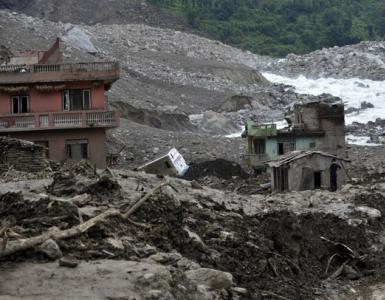
The town of Saint-Jeanne-Vianny in the Canadian province of Quebec was completely abandoned after a landslide in May 1971. The city was built in the 17th century by the first settlers - in a secluded depression on the edge of a giant slope. Its inhabitants lived without any natural disasters for several hundred years. And on May 4, 1971, the first sign of an impending threat followed, when livestock refused to go out into the fields on the edge of the city: most likely, the animals felt minor vibrations in the soil. That same night, a huge landslide occurred. Roads, vehicles and houses were swallowed up by a huge wave of mud 15 meters high, which spread over 15 kilometers within three hours. As a result, 31 people died, and the city is still empty due to strong movements of the layers of clay lying underneath.
THE BIGGEST LANDSLAND IN ITALY'S HISTORY
The Piave River Valley is located in northern Italy and thanks to E. Hemingway’s novel “A Farewell to Arms!” familiar to millions of people. During the First World War, the Italian army was stationed here, operating against the Austrians after their defeat at Caporetto. On October 9, 1963, at 23.15, a terrible natural disaster occurred - the entire valley of the Piave River was flooded. There were reports that the 260-metre Valmot Dam had collapsed under the pressure of a massive landslide caused by the earthquake.
The world's tallest dam, more than 20 meters thick, withstood the earthquake. It collapsed a little later. As the surviving witnesses of the disaster recall, the roar that was heard before the huge water shaft collapsed into the valley had a different origin. It came from the mountains that had cracked on either side of the dam. There is testimony from Captain Fred Mickelson, the pilot of the US military helicopter that evacuated the residents of the village of Casso. The village stood above a dam and was in danger of residual landslides. He described the event as follows: “Behind the dam there was a lake about two kilometers long, but now it is no longer there. The tops of the rocks on both sides of the dam fell into the lake and literally filled it.”
The water forced out of the lake poured through the dam, destroying it, and with a giant waterfall 450 meters high at right angles it poured into the valley of the Piave River.
Longaron, a village located in the path of the water flow, disappeared instantly. 3,700 of the 4,000 inhabitants died. In Pigaro, only the bell tower, the cemetery chapel and one house survived. Until now, no one lives in the village.
THE WORST LANDSIDE IN EUROPE
For centuries, mountains of waste rock grew in the vicinity of mining towns such as Aberfan, in Wales (England), being an integral attribute of the mines. Due to their composition, such mountains are very unstable and mobile. In Aberfan, a stream flowed under the mountain, which, washing away the base, further reduced its stability. A few days before the disaster, local residents noticed some movement on the mountain and notified authorities.
On the morning of October 21, 1966, a representative of the municipal government climbed the mountain to check the information received. While he was inspecting the mountain, suddenly two million tons of rock began to move and fell on the city. The roar was heard several kilometers from the town. Rescue work began immediately, the miners rose to the surface and, together with the townspeople, began excavations. 43 people died - mostly children who were at school at the time.
LANDSlide, separation and sliding movement of a mass of rock down a slope; the sheer mass of displaced rock. O. are common in areas where weak plastic and impermeable rocks are covered by relatively strong permeable ones. The weakening of the strength of rocks is caused by natural causes (increasing the steepness of the slope, washing away its bases by waves and as a result of river erosion, waterlogging of soils with melt and rainwater, infiltration pressure in the rock mass caused by fluctuations in sea level, reservoir or river water, seismic tremors, etc. ) or human intervention (destruction of slopes by mountain and road excavations, excessive grazing or watering, deforestation, improper agricultural practices of slope agricultural lands, construction load on the edge or upper part of the slope, etc.). The emergence and activation of water is facilitated by the technogenic rise in groundwater levels on the banks of reservoirs. O. shift along the slope by several meters, often by tens and hundreds of meters. The volume of displaced rocks ranges from several tens of m3 to 1 billion m3. Large lakes form on steep slopes. 15° at a distance from watersheds, often occur on the sides of valleys, high shores of seas, lakes and reservoirs. They retain a certain coherence and solidity inside the landslide body, the thickness reaches 10–20 m or more. Small lakes transform the sides of ravines everywhere. Often O. are located on a slope in several tiers (for example, in the valley of the Moscow River).
In plan, landslides often have the shape of a crescent, forming a depression in the slope (the so-called landslide circus). Shallow cirque-shaped dents on the steep slopes of valleys and ravines - osovy - appear as a result of surface displacements of highly moistened loamy masses, especially with the slow melting of snow on shady slopes. After the rock is torn off and disappears, a bare surface or niche remains on a steep slope—a landslide ledge. Landslide breccia accumulates at the foot of the slope. A pressure landslide shaft may appear in front of the moving lake front. The tongue of the lake often extends into the waters of a watercourse or reservoir, changing the configuration of the coastline. The basis of the slide is the base of the slope or a separate flattened section of the slope, where the movement of landslide masses stops. Free sliding of a landslide body occurs if the shifting blocks are developed above the base of the slide; in the case when the thickness of plastic rocks lies below, these rocks are squeezed out, accompanied by their movement against the general slope (O. squeezing out I). Rocks that have not lost the natural composition of rocks in their blocks are classified as structural rocks. In “cutting” rocks, the sliding surface cuts off different layers of rocks. When fine particles of fine earth are washed out from the base of the lake by spring waters, weakening the stability of the overlying rocks, it is classified as a type suffosion O. (widely distributed on slopes with a steepness of 10–18°). Possible landslides-flows with a fluid consistency of soil, their volume can reach millions of m3. Small surface water-saturated lakes—slides (width up to several meters, depth from 0.3 to 1.5 m) are formed under conditions of excessive moisture to a plastic (mud-like) or fluid state.
Slopes susceptible to landslide processes are characterized by pseudo-terraces (often with a reverse slope), mounds, swampy closed or poorly drained semi-closed depressions and other forms of landslide relief, as well as a specific appearance of vegetation (for example, the so-called drunken forest). In O.'s body, rupture cracks are observed. In the European part of Russia, lakes are distributed along the sides of the valleys of large rivers (especially the Volga and its tributaries), reservoirs, and along the Black Sea coast. The coasts of the Black Sea are marked by powerful landslide activity - in Crimea, near Odessa (Ukraine) and in Adjara (Georgia). A wide strip of water stretches for hundreds of kilometers along the coasts of the Mangyshlak Peninsula (Kazakhstan). Landslide danger is observed in most mountainous countries (the eastern periphery of Tibet, the Himalayas, etc.). Lakes that come down from the sides of mountain valleys often form temporary dams that dam the river, forming a landslide lake. The catastrophic consequences of a flood wave resulting from the destruction of such a dam many times exceed the negative consequences of the displacement of the reservoir itself. Great damage to the reservoir is caused to agriculture. lands, industrial enterprises, populated areas, etc. To combat them, bank protection and drainage work, forest planting, and securing slopes with piles are carried out.
On relatively steeply inclined areas of the bottom of oceans, seas, and deep lakes in seismically and volcanically active zones, as well as on the frontal slopes of underwater deltas (as a result of sharp differences in sedimentation rates), underwater oceans are found; one of the largest is the Sturegga landslide in the Norwegian Sea (length approximately 800 km, width 290 km). Underwater oxygen can cause the rupture of submarine cables, which has happened repeatedly, in particular, at the bottom of the Atlantic Ocean.
Table. Catastrophic landslides*
Location (current geographic location indicated) | Event characteristics | Volume of solid waste, m3 | Devastating consequences and loss of life |
|
|---|---|---|---|---|
980 BC e. | No data | Destruction. Death of "an enormous number of people" |
||
373–372 BC e. | Greece, North coast of the Peloponnese Peninsula | Seismogenic landslide | The disaster led to the immersion of the ancient city of Helios and a kilometer-long stretch of coast into the waters of the Gulf of Corinth |
|
Beginning of the century e. | Iran. River valley Saidmarreh | The largest landslide from Mount Kabir-Bukh crossed a valley 8 km wide and crossed the high ridge. 450 m | When the river was blocked by a landslide body, a dammed lake 65 km long and up to 180 m deep was formed |
|
Jordan. City of Jarash | Natural-anthropogenic mudflow-landslide disaster | More than 100,000 | Burial under landslide masses and mudflow flood b. including the large ancient city of Geras |
|
Russia. City of Nizhny Novgorod | Catastrophic landslide after heavy rainfall | No data | 150 households were buried. More than 600 people died. |
|
Seismogenic (?) landslide | No data | The village of Hanko is buried under a landslide mass. 2000 people died. |
||
Russia. South coast of Crimea. Village Opolznevoye | The largest in the South. coast of Crimea in historical time seismogenic Kuchuk-Koi landslide and rock flow | The village was destroyed. A large stream disappeared into the hole. The tongue of the landslide advanced into the Black Sea by 100–160 m |
||
China. Gansu Province. Center. part of the Loess Plateau. | 7 seismogenic landslides of large volumes of loess strata, moving entire hills, cutting off mountain slopes | No data | Numerous people were buried. inhabited loess caves, farms and villages. St. died 200 thousand people |
|
Canada. Atlantic. coast | The underwater landslides provoked an underwater turbidity current 330 km wide and (consequence of an earthquake on the Great Bank of Newfoundland at a depth of 800 m) | 7 submarine cables were torn and buried at a distance of up to 1000 km from the epicenter. A wave arose that hit the south. shore of the island Newfoundland. Several villages were destroyed. 33 people died. |
||
China. Sichuan Province | Seismogenic landslide of Deihi | Dam break on the river Min. In the city of Deihi, 577 people died. |
||
Japan. Honshu Island, Kobe area | Landslide caused by heavy rains | No data | 100,000 houses were destroyed in the city. 600 people died. |
|
Japan. Kyushu Island, Kure City District | No data | 2,000 residential buildings were severely damaged or destroyed. 1154 people died. |
||
Cerro Condor-Sencas landslide | A 100-meter dam on the river was destroyed. Rio Montara (followed by flooding) |
|||
Tajikistan. The junction of the Zeravshan and Alai ranges | Landslide as a result of the Khait earthquake | On the right bank of the river. Surkhob, the village of Surkhob was buried, the village of Yarkhich was destroyed, nearby villages were destroyed. The villages of Khait and Khisorak were flooded. 7200 people died. |
||
China. Tibet - Himalayas, near the Indian-Chinese border | Numerous seismogenic collapses and landslides of loose rocks saturated with water from monsoon rains | Enormous changes in relief near the epicenter |
||
Japan. Honshu Island. Wakayama Prefecture | The landslide, caused by heavy rains that destroyed a series of dams, turned into a mudflow along the river. Arida | No data | 1046 people died. |
|
Japan. Honshu Island. Kyoto Prefecture | Minamiyashiro landslide caused by heavy rains | No data | 5,122 houses were destroyed. 336 people died. |
|
Russia. Ulyanovsk city | Large landslide on the right bank of the Volga | The drainage gallery is deformed |
||
Japan. Honshu Island. Shizuoka Prefecture | Kanogawa landslide caused by heavy rains | No data | 19,754 houses were destroyed or severely damaged. 1094 people died. |
|
USA. Montana | Landslide triggered Hebjen earthquake | The landslide blocked the river. Madison, creating a dammed lake. 28 people died. |
||
Italy. Province of Belluno. Vayonta Reservoir | As a result of the erosion of the shore, the Vayont landslide quickly descended into the lake | High waves appeared. 260 m and 100 m. Villages in the river valley were destroyed. Piave. The city of Longarone was severely damaged. 3000 people died. |
||
USA. State of Alaska. City of Anchorage | Seismogenic landslides and collapses | The wave generated by the displacement of landslide masses flooded the port facilities. 106 people died. |
||
China. Yunnan Province | Seismogenic (?) landslide | 4 villages destroyed. 444 people died. |
||
Great Britain. Wales. City of Aberfan | Technogenic landslide as a result of the collapse of the top of a waste heap | No data | 144 people died. |
|
Brazil. City of Rio de Janeiro | A landslide caused by heavy rains, which turned into an earth avalanche and a mudflow | No data | Approximately died. 1000 people |
|
Brazil. East slopes of the Brazilian plateau. Serra daz Araras | Landslide in the Ribeirão da Floresta valley caused by heavy rains | No data | A section of the highway has been demolished, the road builders' camp has been flooded by the landslide, and that means... part of the nearest village |
|
USA. Virginia | Flooding caused by Hurricane Camille contributed to large landslides | No data | More than 100 people died. |
|
Canada. Quebec. City of Saint-Jean-Viony | Liquefied clay of water-glacial origin flowed along the river valley. Petit Bras at a distance of 2.8 km and disappeared into the river. Seguenay | More than 7 million | The embankment on the river was destroyed. Petit Bras. More than 40 houses were destroyed. 34 people died. |
|
Uzbekistan. Pos. Brichmulla | Technogenically provoked activation of the Mingchukur landslide during the filling of the Charvak reservoir | 25–30 million | Partial filling of the reservoir bowl with landslide mass |
|
USA. Western State Virginia. Buffalo Creek Township | The collapse of three coal waste heaps (as a result of heavy rains) caused a landslide that advanced 2–4 km | No data | 4000 people were left homeless. 125 people died. |
|
Peru. River valley Mantaro | Giant Mountmark landslide blocks riverbed | The village was destroyed. Mountmarka. A dammed lake 31 km long (depth up to 170 m) was formed. 450 people died. |
||
Abkhazia. River pool Tskhenis-Tskali | Lashadura tectono-seismogenic landslide | |||
Guatemala | Seismogenic landslide | No data | 200 people died. |
|
Sweden. Gothenburg area | The landslide caused by heavy rains covered a distance of 100 to 175 m | 3–4 million | 67 houses were destroyed. 600 people were left homeless. 1 km of road destroyed. 60 people were injured. 9 people died. |
|
Abkhazia. River pool Kelasuri | Kelasur tectono-seismogenic landslide | Revival of movements of the Holocene landslide, creating the danger of a large-scale collapse |
||
Uzbekistan. Tashkent region. | Technogenically provoked (as a result of siltation of the Pskem River canyon) activation of the Bashkaragach landslide on board the bowl of the Charvak reservoir | Abrupt partial filling of the reservoir bowl and the formation of a high wave |
||
France. Nice city | Underwater landslide transformed into a turbidity current | A part of the river delta is involved in the landslide. Var and the railway. Wave high 3 m spread over 120 km of coastline, damaging communications and harbors. 2 submarine cables were broken at a distance of 120 km from the city of Nice. Several people died. |
||
Uzbekistan. Tashkent region | The Zagasan-Atchinsky landslide, technogenically provoked by the mining of a coal deposit and underground gasification of coal on the side of the river valley. Angren (on a slope at an altitude of 600 m). The displacement plane is located at a depth of 130 m. | Forced transfer of more than 2,000 houses to the opposite bank of the river. Filling 50 million m3 of soil to stabilize the landslide |
||
China. Hubei Province. | Landslide (Yanchihe earth avalanche), technogenically provoked by the development of a phosphorite deposit | 284 people died. |
||
USA. California State. Area hall. San Francisco | Storm and catastrophe. floods caused several large landslides | No data | 6,500 residential buildings, 1,000 industrial buildings were damaged or completely destroyed. enterprises and institutions. 30 people died. |
|
USA. Utah | Landslide caused by melting snow and heavy rainfall | Record-breaking landslide in US history ($600 million) |
||
China. Gansu Province. | Saleshan landslide caused by heavy rains | 4 villages destroyed. 237 people died. |
||
Chunchi landslide caused by heavy rains and rapid snow melt in the Andean highlands | 150 people died. |
|||
Puerto Rico. Center. part of the island. City of Mamayes | Landslide caused by heavy rains. | 129 people died. |
||
The Reventador earthquake triggered the landslide of the same name | 75–110 million | 1000 people died. |
||
Brazil | Petropolis landslide caused by heavy rains | 300 people died. |
||
Tajikistan. Gissar Valley | Several seismogenic landslides (as a result of the Gissar earthquake), the largest of them is 3700 m long, 600 m wide, up to 28 m thick | The liquefaction of the landslide mass led to the formation of a mudflow that advanced several kilometers, causing destruction and human casualties. |
||
China. Sichuan Province | Hiksu landslide caused by heavy rains | No data | 221 people died. |
|
China. Yunnan Province | Touzahi landslide caused by heavy rains | 216 people died. |
||
Colombia. Cauca Department | Seismogenic Paes landslide caused by one. earthquake | No data | Covered area sq. 250 km2. 1,700 people went missing. 272 people died. |
|
India. Himalayas. Malpa | Landslide caused by heavy rain | No data | 221 people died. |
|
Papua New Guinea. North-west coast. | Powerful seismogenic underwater landslide | No data | A wave arose, the victims of which were 2000 people. |
|
Seismogenic landslide Ju Feng-er-shan | No data | At least 119 people died. |
||
China. Tibet. | The Yangong landslide, triggered by the rapid melting of snow and ice. | 500,000 people were left homeless. 109 people died. |
||
Salvador. Suburb of San Salvador Las Colinas | Seismogenic landslide (epicenter in the Pacific region) | No data | 4,692 houses were destroyed. More than 1000 people went missing. 585 people died. |
|
Russia. Saratov region Volsk city. East slopes of the Volga Upland | Natural-man-made landslide in the center. parts of the city | 321 families living in 237 houses were resettled |
||
Sri Lanka | Landslide and mudflow caused by heavy rains | No data | 24,000 buildings destroyed. 260 people died. |
|
Pakistan, India (Kashmir, vicinity of Muzaffarabad) | Seismogenic landslides and rockfalls | 80 million (Hattien Bala debris avalanche) | The avalanche blocked the channels of two tributaries of the river. Jhelum, village buried (1000 victims). In total, 25.5 thousand people died. |
|
Philippines. Luzon Island. Albay Province | Landslides and avalanches caused by heavy rains (Typhoon Durian) | 1100 people died. |
||
China. Sichuan. Neighborhood of Chengdu | Seismogenic landslides, debris avalanches and mudflows | No data | 20 thousand people died. |
|
Egypt. East (upland) part of Cairo | Al-Duwaiqi man-made landslide as a result of construction work in the edge of the plateau | No data | 107 people died. |
|
Afghanistan. Baghlan Province | Seismogenic landslide | No data | More than 20 houses were buried. 80 people died. |
|
Uganda. District national Mount Elgon Park (near the border with Kenya) | Landslide caused by heavy rains | No data | 18 people died. |
|
Japan. Honshu Island. Hiroshima | Landslide caused by heavy rains (204 mm of precipitation in 3 hours) | No data | Destruction in the city. Several people died. |
|
Georgia. Tbilisi city | Landslide caused by heavy rains | No data | It blocked the Vere River gorge and caused flooding in Tbilisi. Mass death of animals at the Tbilisi Zoo. 19–22 people died. |
|
Kyrgyzstan. Almalyk south of Osh | Catastrophic landslide | No data |
||
Sri Lanka | Landslide caused by heavy rains | No data | 180 people were left homeless. 7 people died. |
*The table shows landslides that led to large-scale destruction (including on the seabed), or to numerous casualties, or to a fundamental negative change in the natural landscape.
This is one of the most terrible disasters of the twentieth century, about which almost nothing is still known. Information about the tragedy that occurred in 1949 in Tajikistan was hidden from the outside world by the Stalinist regime.
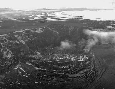
The Pamir mountain range, which borders China and Afghanistan in the east of Tajikistan, has for centuries been an area reluctant to be visited by foreigners. In the 19th century, he found himself at the epicenter of the ongoing struggle for spheres of influence that unfolded between the Tsarist government of Russia and Great Britain. Tajikistan's entry into Russia as a sovereign republic after the 1917 revolution made access to the region virtually impossible. But still, occasionally, with the permission of the ruling regime, climbers appeared in the Pamirs; for some time there was even a Russian-American station there, dealing with seismology. The Pamirs were and continue to be a unique region that still retains increased underground activity, often providing convincing evidence of this. So, as a result of the earthquake of 1911, a new lake appeared, called Sarez. Its length is 60 km, and its depth in some places reaches 500 m.
According to sad statistics obtained by the country's authorities, an avalanche of rocks and landslides in the winter of 1999 in northern Venezuela killed 30,000 people, injured 20,000, left thousands homeless, and razed 100,000 houses to the ground.

Landslides washed away all the dilapidated houses and shacks around the city of Caracas. Coastal areas north of the Venezuelan capital Caracas were littered with stones, giant boulders, river mud and silt brought by an avalanche from the El Avila mountain range, which separates Caracas from the Caribbean Sea. The cause of the unexpected avalanches on December 15 and 16, 1999 was heavy rainfall that hit the mountain peaks. Fragments of loosened and collapsed stones and boulders rolled down with terrible speed. It is not surprising, because the amount of precipitation that fell in two weeks in the mountains of Venezuela was 24 times higher than the monthly norm. Streams of mud, stones and debris washed away everything in their path: houses, trees, cars, people rushing down the mountains. The flows stopped only after mixing with the waters of the Caribbean Sea. Satellite photographs clearly show the entire path of the landslide.
Landslides have become a common occurrence in Indonesia in recent decades. The most destructive events occurred on the island of Sulawesi (Indonesian archipelago) in June 2006.

The landslides in the south of Sulawesi were caused by heavy rains that began on June 18, 2006, and lasted for three days. As a result, huge flows of water washed away large layers of earth from the hills and mountains and flooded the valleys. Severe floods began in the southeastern part of the province of South Sulawesi: Sinjai, Bulukumbang, Bantaeng, Luvu Utara, Bone, Gowa, Sidenreng Rappang. The Sinjai area suffered the most: people there lived in small huts on the hills and were taken by surprise. “We heard the sound of approaching water and rushed to save our lives,” says a resident of the village of Gantarang, which was hit by a powerful stream. “But not everyone managed to get out of their houses in time, and they drowned in the streams of mud that demolished their houses.” When the water receded, residents began to dig out their homes and found several survivors. “It seemed almost impossible because we had simple tools and the rain just wouldn’t stop.”
As landslide statistics show, 80% of these phenomena are associated with human activity, and only 20% with natural phenomena.
Landslides
Rock falls can form on any inclined surface of the earth, regardless of the steepness of the slope. The occurrence of landslides is influenced by river floods, erosion of slopes, soil displacement from, road construction associated with soil excavation.
Landslide statistics highlight the main causes of their formation - natural and artificial. Natural ones are produced by natural phenomena, artificial ones by human activity.
Causes of rock destruction
To understand , How landslides are born, we should consider the causes of their occurrence, which are divided into three groups:
- violation of the shape of the slope a – can be caused by rain washouts, river floods, artificial excavation;
- change in rock structure, making up the slope. This is typically caused by groundwater dissolving the salt deposits that bound the rock. The texture of the soil becomes looser, which increases the risk of its destruction;
- increase in ground pressure. Soil vibrations, artificial loads of man-made objects, as well as groundwater pressure that entrains particles along the way.
The influence of rain is associated with physical destruction of the slope, increased soil looseness and increased pressure on the slope.
Systematization of types of landslides
There are different ways to classify a natural phenomenon. Landslides are divided by material: snow (avalanche) or stone. For example, there is a mountain landslide in the area. According to the mechanism of the ongoing process. A landslide caused by heavy rain develops into a mudslide, and the resulting mudslide rapidly moves down the river, destroying everything in its path. According to the mechanism of occurrence, the following types of geomorphological phenomena are distinguished:
- Compression landslides. They are formed when the soil is deformed under vertical pressure, and compression of the layers occurs. The upper part of the massif sags and forms a deflection, in which a crack appears under the influence of the resulting stress. Part of the rock breaks off and begins to move. Typical for clay soil.
- Shear landslides. Occur during the accumulation of shear stresses, are formed on steep slopes, the rock slides and slides along the surface. Sometimes such phenomena are formed at the boundary of rocks, then significant massifs can “slide”, often the soil layer slides (slide).
- Liquefaction landslides associated with the impact of groundwater. They occur in rocks with a weakly cohesive structure under the influence of hydrodynamic and hydrostatic water pressure. Depends on groundwater levels and rainfall. The phenomenon is typical for clay and loamy soils, peat and soil structures.
- Tensile landslides associated with detachment, spalling of a part of the massif under the action of tensile stresses. Rocky formations begin to collapse when the permissible stress is exceeded. Sometimes ruptures occur along tectonic cracks.
There is also a division of landslides according to the scale of the process occurring.
Landslides and mudflows
Landslides and avalanches, as well as landslides and mudflows, are very similar in their causes of origin. Collapses can form due to chemical reactions occurring in the rock when water leaches the rock and breaks down structural bonds, forming caves underground. At some point, soil falls into this cave, forming a sinkhole. Landslides are also associated with craters that are formed when rock falls.
Mudflow formation pattern - heavy rains wash solid particles into the river bed, which move downhill at high speed.
The most dangerous regions
For a landslide to occur, the presence of a slope with a slope of more than 1° is sufficient. On the planet, ¾ of the surface meets these conditions. As landslide statistics show, such phenomena most often occur in mountainous areas with steep slopes. And also in places where fast, full-flowing rivers with steep banks flow. The mountainous coastal shores of resort areas are prone to landslides, on the slopes of which a large number of hotel complexes have been built.
There are known areas of landslides in the North Caucasus. Dangers exist in the Urals and Eastern Siberia. There is a threat of landslides on the Kola Peninsula, on Sakhalin Island, and the Kuril Islands.
In Ukraine, the last landslides occurred in Chornomorsk in February 2017. This is not the first time, since the Black Sea coast regularly “gives” such surprises. In Odessa, old-timers remember cleanup days for planting trees in places where soil displacement occurs. The existing coastal development with high-rise buildings in the coastal zone is contrary to the norms and regulations for construction in landslide areas.
The Ingulets River is one of the largest and most picturesque rivers in Ukraine. It is very long, expands and contracts, and washes the rocks. The risk of rock falls on the Ingulets River arises from the following points:
- the city of Krivoy Rog, where the river flows in contact with rocks up to 28 meters high;
- the village of Snegirevka, where the natural monument “Nikolskoe Settlement of Snakes” is located downstream - an area with a very steep bank.
Modern realities
In April 2016, a landslide in Kyrgyzstan caused the death of a child. The occurrence of the collapse is associated with heavy rains that occurred in the foothill areas. There are 411 places in the country where there is a danger of landslides.
The clayey soil, almost 10 meters deep, retains moisture, which is well compensated by thick grass, which evaporates excess liquid. But the human factor - regular mowing and construction of roads between hills upsets this balance. As a result, frequent landslides destroy settlements and sometimes kill people.
The most tragic landslide in Kyrgyzstan occurred in 1994, when the number of victims reached 51 people. After this, the government decided to remove residents from dangerous areas. 1,373 families were asked to evacuate, plots were allocated for this purpose and loans were issued. However, having received land and material assistance, 1 thousand 193 families remained to live in their places.
Landslide statistics show that the entire right bank of the Volga is an area of regular landslides. Heavy rains and rising ground river levels provoked a landslide in Ulyanovsk in April 2016. 100 meters of the roadway collapsed, the landslide almost reached the railway embankment.
In September, landslides and landslides occurred in the Crimea in the village of Nikolaevka. Two people died, about 10 were trapped under the rubble. The proximity of the Black Sea is a factor in the formation of landslides for this region. Most vacationers prefer “wild” holidays in places prohibited for swimming, where there is a high risk of soil melting. does not stop the landslide, they are located in dangerous areas, risking life and health.
The most destructive collapses on the planet
Landslides are not considered the most dangerous of natural phenomena. That's why people don't take them seriously enough. Statistics of landslides in the world:
| Year | Landslide site | Causes | Consequences |
| 1919 | Indonesia | 5,110 people died | |
| 1920 | China | Earthquake | More than 100,000 victims |
| 1920 | Mexico | Earthquake | More than 600 victims |
| 1938 | Japan | Showers | 505 victims |
| 1964 | USA in Alaska | Earthquake | 106 victims |
| 1966 | Brazil | Heavy rains | Approximately 1000 victims |
| 1976 | Guatemala | Earthquake | 200 victims |
| 1980 | USA, Washington state | Eruption | The largest landslide in the world, evacuation of the population, 57 victims |
| 1983 | Ecuador | Rain and melting snow | 150 victims |
| 1985 | Colombia | Eruption | 23,000 victims |
| 1993 | Ecuador | Mining activities | Numerous destructions, no fatalities |
| 1998 | India | Pouring rain | 221 victims |
| 1998 | Italy | Shower | 161 dead |
| 2000 | Tibet | Snow melting | 109 dead |
| 2002 | Russia, North Ossetia | The collapsed glacier created a mudflow | 125 victims |
| 2006 | Philippines | Rains | 1100 victims |
| 2008 | Egypt | Construction work | 107 victims |
| 2010 | Brazil | Heavy rain | 350 victims |
This is far from complete statistics of landslides and their destructive effects in the world. The last collapses caused by heavy rains took place in Georgia in September 2016. Debris has formed on the road in Georgia. The Georgian Military Road was blocked.
Why are landslides dangerous?
At the first stage, the danger comes from collapsing masses of stones and soil. The damaging factors at the second stage are the destruction of roads and communications, damage. Landslides accompanied by downpours, blocking the river bed, can cause. A landslide introducing soil into the river provokes a mudflow, which can intensify the destruction process, increasing its speed. Housing destruction is another danger factor for people.
The disaster in Chechnya in 2016 damaged 45 houses and destroyed 22 buildings. 284 people were left homeless.
How to behave if there is a threat of a rock collapse
As the statistics of landslides show, most of them happen to people who ignore the rules of conduct during a landslide. They suggest the following actions in case of landslides:
- shutdown of electricity, gas and water;
- collection of valuables and documents;
- preparation for evacuation of households;
- closing all windows and doors;
- evacuation to a safe place.
It is important to obtain up-to-date information about the speed of the landslide and its direction. Rules of behavior in mountainous areas contribute to adequate actions in the event of danger. These include knowledge of the speed at which landslide displacement is recommended for evacuation. The time it takes to get ready depends on this.
The accumulated statistics of landslides recommends that when the rate of displacement of the mountain range exceeds 1 meter per day, evacuate to a safe place according to plan. If the traffic is slow (meters per month), you can travel according to your capabilities. In areas where landslides are common, the population knows the safest places in case of landslides. Usually this:
- high areas located on the opposite side of the flow;
- mountain valleys and crevices;
- large stones or powerful trees, behind which there is an opportunity to hide.
The warning system has made great progress over the past 5 years; modern forecasting and warning tools make it possible to minimize human losses.
Landslide prevention
The fight against landslides is aimed at preventing events and measures to reduce losses from them, including measures that reduce human influence on the formation of a landslide. To study the nature of landslides in a specific area, geotechnical surveys are carried out. Based on expert opinions, methods are being developed to reduce the risk factors for landslides. Work is carried out in two directions:
- a ban on human species that contribute to the formation of landslides (deforestation, excavation, weighting of soil by construction of buildings);
- carrying out protective engineering work, which includes: strengthening the banks, draining water, cutting off the active part of the landslide, reinforcing surfaces, retaining structures.
The devastating consequences of landslides can sometimes be prevented. Professor from Great Britain, D. Petley, calculated the number of victims from landslides around the world over the past 10 years. The main damaging factors of landslides claimed the lives of 89,177 people during this time.
 Potentially, landslides in Russia can occur almost everywhere where there is even a slight slope, but in some regions they occur regularly, and in others they are unexpected. In 2015, two shifts occurred in Chuvashia, which came as a surprise to residents. Studies have shown that over the past 5 years there has been a significant shift in soil in areas of elite development. To prevent collapses, studies and a number of protective works to strengthen the slopes were carried out.